StateDMI / Command / ReadParcelsFromHydroBase
Overview
The ReadParcelsFromHydroBase command (for StateCU and StateMod) reads parcels and related supply data from HydroBase
and creates data objects in memory that provide data to other commands,
in particular commands with Parcel in the name.
This "data map" design provides consistency, increases software performance, allows for data quality control,
and minimizes the need for redundant logic in other commands, specifically:
Model / Parcel / Supply Data
Irrigated lands data are digitized using geographic information system (GIS) software, resulting in a spatial data layer for each major basin for a year. The following image illustrates the basic data objects, which rely on the unique identifiers shown to enforce relationships. Ditches are identified using a water district identifier (WDID). Wells are identified using a WDID if the well has a water right or other administrative data, or a well permit receipt identifier if WDID is not available. Modelers should typically use WDID for wells if it is available, although receipt can be used if desired.
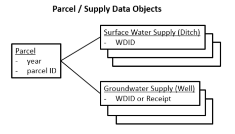
Parcel and Supply Data Objects (see also the full-size image)
The above data objects from GIS and HydroBase do not include modeling constructs such as model identifier,
collections of structures (aggregates, systems), etc.
The parcel and supply data are loaded into HydroBase and relationships are defined
to connect to other information such as structures (ditches and wells), and well physical data.
StateDMI software keeps a list of all individual parcels that are part of the dataset,
with associated supply information, similar to the original GIS data.
Only one copy of each unique year/parcel exists in this list.
Use the WriteParcelsToFile(FileFormat=ParcelSupply) command
to create a report for the data.
The addition of model constructs is represented in the following figure and indicates how parcels are associated with model locations.
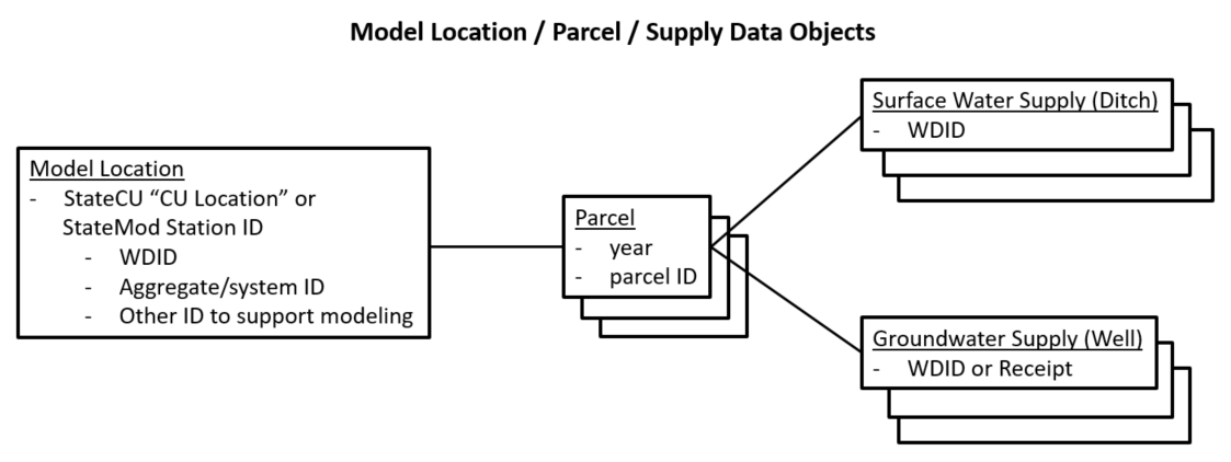
Model, Parcel, and Supply Data Objects (see also the full-size image)
Model locations can be a single diversion (single ditch), a diversion system/aggregate that includes multiple ditches,
or a well system/aggregate (one or more wells).
Currently single wells are not supported and must be defined as a list of 1 well in an aggregate/system.
Model locations that are diversions may result in wells automatically being added as supply
because diversions relate to parcels, which relate to wells.
Parcels can be served by supplies that are in more than one model location.
For example, a parcel may be supplied by a D&W model node that includes a ditch,
and a WEL model node with groundwater-only.
Therefore it is necessary to store the relationship between supply and model location, as shown in the following figure,
in order to properly make decisions during data processing.
Use the WriteParcelsToFile(FileFormat=ModelParcelSupply) command
to create a report for the data.
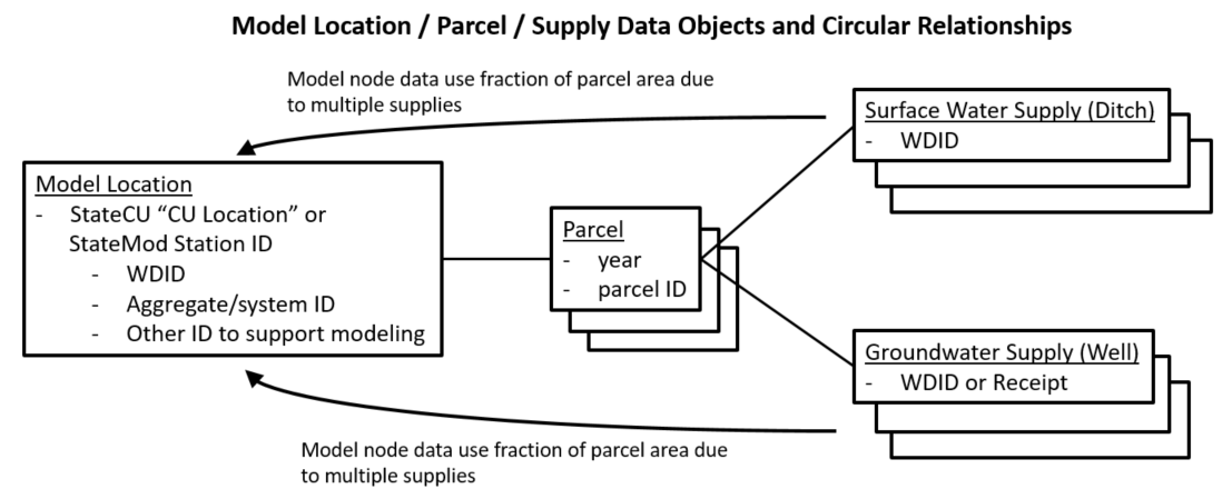
Model, Parcel, and Supply Data Objects with full Relationships (see also the full-size image)
Care must be taken to avoid double-counting irrigated area in the
ReadCropPatternTSFromParcels and
ReadIrrigationPracticeTSFromParcels
commands, which would inflate consumptive use and water demand estimates.
To account for this, the supplies that are associated with a parcel are handled as follows:
- The parcel's fractional area irrigated by each surface water supply ditch is 1/(number of ditches).
- The parcel's fractional area irrigated by each groundwater supply well is 1/(number of wells).
- For wells associated with a ditch in a D&W model node (where wells are automatically determined for involved parcels), the parcel's fractional area irrigated by each groundwater supply well is 1/(number of ditches matching node, for single ditch or ditch in collection)/(number of wells). This area calculation impacts irrigation practice time series but not crop pattern time series (because only parcels with surface water supply are included for D&W nodes).
Consequently, when calculating irrigated area such as for crop pattern time series (*.cds file)
and irrigation practice time series (*.ipy), the supplies for the parcel can be processed and acreage summed
as necessary, such as by crop type, irrigation method, and whether surface or groundwater supply.
The following is a summary of data objects used by StateDMI to process parcel-related data:
- A list of all parcels in the dataset, each of which is uniquely identified by year and parcel identifier.
- For each parcel, a list of supplies identified by ditch (WDID) or well identifier (WDID or receipt).
- Because StateDMI processes model data, each supply's identifier also allows a reference to the model location that includes the supply (next item).
- A list of model locations (StateCU locations or StateMod stations),
each of which has a list of the parcels associated with the location.
- The list of ditches and wells for each location is defined by the model dataset.
- The list of ditches and wells determines the associated parcels (from above).
Therefore, relationships are circular and provide a cross-reference between data objects. The above data are used when processing specific model data files and logic is implemented to ensure that irrigated land is counted only once, regardless of overlapping parcel/supply relationships. Model data files are organized by model location and therefore processing logic typically iterates through the list of model locations and accesses other data objects as needed.
Processing Logic
Processing logic uses internal objects defined in the previous section to ensure that the acreage for a parcel is only counted once for consumptive use calculations. Wells can provide supplemental supply to ditches (commingled supplies), and the acreage in this case is only assigned to the ditch.
The following summarizes the processing logic for each model location (StateCU Location) that is processed. Within each top-level step, processing is limited to years in the entire dataset that have parcel data in the requested period (this ensures that locations that don't have irrigated lands in each year with irrigated lands data will have values set to zero). The following logic is executed twice, with the second iteration only checking for unmodeled well supplies in step 3.e.
- If the CU Location is not a collection (is a single diversion structure),
for example corresponding to a StateMod
DIVorD&Wnode:- Read "parcel use" data (HydroBase
vw_CDSS_ParcelUseTSStructureToParcelview) for the single structure, which provides the following data:- calendar year
- crop type
- total acres for the crop type
- irrigation method
- structure information
- For parcels that are returned, add a parcel record to the data model for each unique year and parcel ID, if not already added.
- For each structure associated with the parcel, add a surface water supply record for the parcel.
- Read "well to parcel" data (Hydrobase
vw_CDSS_WellsWellToParcel view) to determine if the parcel is associated with wells and for each well, add a groundwater supply to the parcel.
- Read "parcel use" data (HydroBase
- If the CU Location is a collection and the collection part type is
Ditch, for example corresponding to a StateModDIVorD&Wnode that is an aggregate or system:- For each structure in the collection, run the process as described above for a single diversion part in the collection, which adds parcels and related water supply if not already added.
- If the CU Location is a collection and the collection part type is
Well, for example corresponding to a StateModWELnode for groundwater only model node specified as an aggregate or system:- For each well in the collection, read data from the HydroBase
vw_CDSS_WellsWellToParcelview, which returns the list of parcels associated with the well and associated well. The well identifier can be either a structure WDID or well permit receipt. - For parcels that are returned, add a parcel record to the data model for each unique year and parcel ID, if not already added.
- For each record from step 1, add a well supply for the parcel, if not already added. This ONLY adds specific wells included in the groundwater-only aggregate/system list. See step 3.e.
- For each parcel read "parcel use" data (HydroBase
vw_CDSS_ParcelUseTSStructureToParcelview) and add a surface supply for the parcel, if not already added. This is necessary in order to account for surface water supplies for ditches that are not included in the dataset. - For the second overall iteration, query all wells associated with the parcel. Any wells that were not previously added are considered as not being in the model dataset. Unmodeled wells will impact the number of supplies and resulting area fractions but the associated fractional area will not be added to crop pattern or irrigation practice time series.
- For each well in the collection, read data from the HydroBase
- If the CU Location is a collection and the collection part type is
Parcel:- This case was implemented for
ReadCropPatternTSFromHydroBaseandReadIrrigationPracticeTSFromHydroBase. - This case is not currently handled for this command but would be similar to the previous case except that parcel/well relationships would be queried using the parcel identifier.
- This case was implemented for
- Else, the input is not understood and a warning is generated.
Additional Technical Considerations
The following are additional technical considerations related to parcel data processing:
- For processing step 3.c above, the internal data management uses an optimized data structure to look up parcel/ditch data. The logic currently requires that the water district is specified when retrieving parcel data. The water district is currently determined from digits 2-3 of the parcel ID, because the first digit is the water division. If the water district for the well being processed is different from the parcel water district, records using both are queries. There may be issues if the results are in different divisions because parcel identifiers may only be unique within the same year and division.
Command Editor
The following dialog is used to edit the command and illustrates the command syntax.
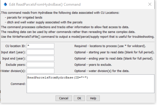
ReadParcelsFromHydroBase Command Editor (see also the full-size image)
Command Syntax
The command syntax is as follows:
ReadParcelsFromHydroBase(Parameter="Value",...)
Command Parameters
| Parameter | Description | Default |
|---|---|---|
ID required |
A single CU Location identifier to match or a pattern using wildcards (e.g., 20*). |
None – must be specified. |
InputStart |
Starting year to read data. | All available parcel data will be read. |
InputEnd |
Ending year to read data. | All available parcel data will be read. |
ExcludeYears |
Years to exclude, separated by commas, necessary if HydroBase has years with erroneous data that should be ignored. | All years will be used to auto-fill area with zero if no crop data in those years. |
Div |
Water divisions to process, separated by commas. Specifying this will increase performance slightly but the default behavior simplifies input. | Determine divisions based on location identifiers that match the format of water district identifiers (WDIDs) . |
Examples
See the automated tests.
Troubleshooting
The following are troubleshooting suggestions based on experience.
| Error Example | Suggestion |
|---|---|
CU location "10_GW104 part ID "1005163" has HydroBase vw_CDSS_ParcelUseTS (as ditch) and vw_CDSS_WellsWellToParcel (as well) data records. |
Possible causes include:
|
Error getting well/parcel data for year 2017, receipt=9078680 (java.lang.IllegalArgumentException: The water district (-1) is invalid. Must be 1+). |
Possible causes include trying to use a well receipt that cannot be found:
|
See Also
CheckParcelscommandReadCropPatternTSFromParcelscommandReadIrrigationPracticeTSFromParcelscommandReadWellRightsFromHydroBasecommandWriteParcelsToFilecommand