TSTool / Command / ReadUsgsNwisDaily
Overview
The ReadUsgsNwisDaily command reads one or more time series from the
United States Geological Survey (USGS) National Water Information System (NWIS)
Daily Value web service (see the UsgsNwisDaily Data Store Appendix).
The command provides parameters to constrain the web service query
and also allows the result to be saved as an output file.
For example, if WaterML is chosen as the time series format,
a WaterML file can be saved and can be read later using the
ReadWaterML command.
See also the WebGet command, which also can be used to retrieve data files from the USGS website.
The USGS NWIS web service allows station and time series data type information to be filtered, both as a convenience and to maintain reasonable web service performance. Many of the choices that are available for limiting queries allow 0+ values to be provided. For example, specifying no requested parameter will return all available parameters for a location. Specifying a list of parameters (separated by commas) will return only the requested parameters.
USGS codes are used in order to generate a unique time series identifier (TSID).
For example, the TSID data type is formed from the parameter code, a dash, and the statistic code.
The numerical codes currently are used to ensure uniqueness
but in the future the string name may be allowed as an option.
In order to have more human-friendly identifiers for time series,
one strategy is to request only a specific parameter and statistic
and then use the alias to specify a text equivalent to the numeric codes.
For example, specify Parameters=00060 (for streamflow discharge) and Statistics=00003 and
assign the alias with Alias=%L.Streamflow-Mean.
Command Editor
The following dialog is used to edit the command and illustrates the syntax. Note that some choices are provided as a convenience. However, full listing of choices (such as all the thousands of streamflow stations that are available) is not provided due to performance issues. Additional query features will be enabled as web service integration is enhanced.
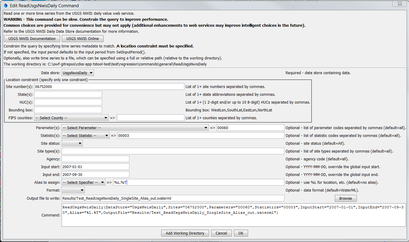
ReadUsgsNwisDaily Command Editor (see also the full-size image)
Command Syntax
The command syntax is as follows:
ReadUsgsNwisDaily(Parameter="Value",...)
Command Parameters
| Parameter | Description | Default |
|---|---|---|
Sites |
A list of site numbers to read, separated by commas. Can be specified using ${Property} syntax. |
None – one of the locational parameters must be provided to constrain the query. |
States |
A list of state codes (e.g., AL), separated by commas. Can be specified using ${Property} syntax. |
None – see above. |
HUCs |
A list of hydrologic unit codes, separated by commas. See the limitations on the NWIS site for more information. Can be specified using ${Property} syntax. |
None – see above. |
BoundingBox |
A bounding box consisting of west longitude, south latitude, east longitude, and north latitude, separated by spaces. Longitudes in the western hemisphere are negative. Can be specified using ${Property} syntax. |
None – see above. |
Counties |
A list of Federal Information Processing Standards (FIPS) county codes, separated by commas. Can be specified using ${Property} syntax. |
None – see above. |
Parameters |
Data parameter codes for the stations (e.g., 00060 for stream discharge), separated by commas. Can be specified using ${Property} syntax. |
All available parameters are returned. |
Statistics |
Statistic codes (e.g., 00003 for mean), separated by commas. Can be specified using ${Property} syntax. |
All available statistics are returned. |
SiteStatus |
Filter for stations, one of:
|
All |
SiteTypes |
Site types to return, separated by commas. Can be specified using ${Property} syntax. |
All available site types are returned. |
Agency |
Agency code to return (e.g., USGS). Can be specified using ${Property} syntax. |
All available agencies are returned. |
InputStart |
The start of the period to read data – specify if the period should be different from the global query period. Can be specified using ${Property} syntax. |
Use the global query period. |
InputEnd |
The end of the period to read data – specify if the period should be different from the global query period. Can be specified using ${Property} syntax. |
Use the global query period. |
Alias |
The alias to assign to the time series, as a literal string or using the special formatting characters listed by the command editor. The alias is a short identifier used by other commands to locate time series for processing, as an alternative to the time series identifier (TSID). |
None – must be specified. |
Format |
The data format for output, one of:
|
WaterML |
OutputFile |
The name of the output file to create. The path to the file can be absolute or relative to the working directory. Can be specified using ${Property} syntax. |
No output file will be created. |
Examples
See the automated tests.
Troubleshooting
See Also
ReadUsgsNwisGroundwatercommandReadUsgsNwisInstantaneouscommandReadUsgsNwisRdbcommandReadWaterMLcommandWebGetcommand