TSTool / Datastore Reference / NDFD
Overview
Integration of TSTool and NDFD was tested on a project in the mid-2000s but is not an active feature. Additional resources are needed to implement a current solution for accessessing similar information using current web services. This documentation is retained for reference and may be removed in the future.
The National Digital Forecast Database (NDFD) XML Web Service from the NWS is a web service that sends NDFD forecast data from the NWS web site listed above to a requesting Data Service through the Simple Object Access Protocol (SOAP). The data retrieved is in an XML format as specified by Digital Weather Markup Language (DWML) format and schema.
To use the forecast data, a Data Service will first make a request to the NDFD Web Service via the SOAP for getting either instantaneous or daily average data at the following web address:
http://www.weather.gov/forecasts/xml/DWMLgen/wsdl/ndfdXML.wsdl
This site provides the following forecast data using web services (bold indicates primary data types for data services). See the following table for corresponding data type strings.
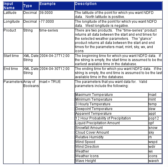
- Maximum Temperature
- Minimum Temperature
- 3 Hourly Temperature
- Dewpoint Temperature
- Apparent Temperature
- 12 Hour Probability of Precipitation
- Liquid Precipitation Amount
- *Snowfall Amount
- Cloud Cover Amount
- Relative Humidity
- Wind Speed
- Wind Direction
- Weather
- Wave Heights
These data can be instantaneous or a daily average and are available as a grid.
This implies that the Data Services can be called iteratively to obtain a geospatial context to the time-series data.
The following tables show the necessary parameters needed to retrieve data from the
NDFD database site for instantaneous and daily average data respectively (Tables courtesy of NWS).
These data are retrieved through a Web service implementing a SOAP interface.
There are two SOAP functions that need to be called by the Data Service implementation:
the first is NDFDgen() which is used to retrieve instantaneous time-series data;
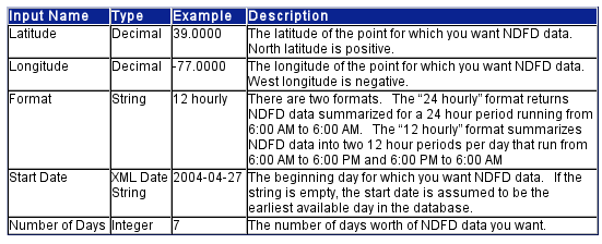
the second function is NDFDgenByDay() that is used to retrieve daily average data.
The following tables reflect the parameters needed to call these two NDFD SOAP functions respectively.
Additional reference information on the NWS NDFD SOAP implementation, functions, and time series input type can be retrieved from the NWS forecast site:
Input Variables to the NDFDgen() Web Service Request
Input Variables to the NDFDgenByDay() Web Service Request
Standard Time Series Properties
The standard time series identifier (TSID) for NWS NDFD time series files is of the form:
Latitude_Longitude.NWS.DataType.Interval~NDFD~Server
Where:
- The TSID location is a latitude and longitude value and will fall within a grid cell of calculated forecast data.
This location is based on the NWS latitude and longitude definition and will have the
form
nnnnnn_mmmmmmwherennnnnnwill be translated tonn.nnnnandmmmmmmwill be translated to–mm.mmmm. These translations are used because the web service only applies to the United States. For example, latitude40.1800and longitude–105.0600would be specified as401800_1050600. - The TSID data source is NWS since the data is coming from the National Weather Service.
- The DataType will be one of the data parameters described in the first table.
Daily average data will only accept
maxt,mint, andpop12parameters. See the following table for a matrix of data types for available for either instantaneous or daily average data. - The Interval is the data interval to retrieve forecast data.
This would be of the form:
nHourwherenis2,3,4,6,8,12, or24for instantaneous data orDayfor daily average data averaged over 24 hours respectively. NDFDis used for the input type.- The Server is an optional parameter to specify the NDFD web service server. Currently there is only one server: http://www.nws.noaa.gov/forecasts/xml that is the default.
Matrix of Data Types
| Data Type | Intervals | Description | SOAP Function Used |
|---|---|---|---|
maxt |
2,3,4,6,8,12,24, or day | Maximum instantaneous or daily average temperature over a given time period | NDFDgen() and NDFDgenByDay() |
mint |
2,3,4,6,8,12,24, or day | Minimum instantaneous or daily average temperature over a given time period | NDFDgen() and NDFDgenByDay() |
temp |
2,3,4,6,8,12, or 24 | Instantaneous temperature at the time interval at the time interval over a given time period | NDFDgen() |
dew |
2,3,4,6,8,12, or 24 | Instantaneous dew point temperature at the time interval over a given time period | NDFDgen() |
pop12 |
2,3,4,6,8,12,24, or day | 12 hour probability of precipitation over a given time period | NDFDgen() and NDFDgenByDay() |
qpf |
2,3,4,6,8,12, or 24 | Instantaneous liquid precipitation amount at the time interval over a given time period | NDFDgen() |
appt |
2,3,4,6,8,12, or 24 | Instantaneous apparent temperature at the time interval at the time interval over a given time period | NDFDgen() |
snow |
2,3,4,6,8,12, or 24 | Instantaneous snowfall amount at the time interval over a given time period | NDFDgen() |
sky |
2,3,4,6,8,12, or 24 | Instantaneous cloud cover at the time interval over a given time period | NDFDgen() |
rh |
2,3,4,6,8,12, or 24 | Instantaneous relative humidity at the time interval over a given time period | NDFDgen() |
wspd |
2,3,4,6,8,12, or 24 | Instantaneous wind speed at the time interval over a given time period | NDFDgen() |
wdir |
2,3,4,6,8,12, or 24 | Instantaneous wind direction at the time interval over a given time period | NDFDgen() |
wx |
2,3,4,6,8,12, or 24 | Instantaneous weather conditions at the time interval over a given time period | NDFDgen() |
waveh |
2,3,4,6,8,12, or 24 | Instantaneous wave height at the time interval over a given time period | NDFDgen() |
Limitations
The NDFD input type has the following limitations:
- Latitude and longitude rather than a station ID specifies the location. Therefore to retrieve data at a location matching a station, the latitude and longitude of the station must first be determined.
- The NWS NDFD web service only serves data for the United States. Thus a request that uses a latitude and longitude that falls outside the United States will return missing data.