TSTool / Command / WriteTableToGeoJSON
Overview
The WriteTableToGeoJSON command writes a table to a GeoJSON file,
which is a spatial data format that can be viewed in geographic information system (GIS) software and other visualization tools. See:
- GeoJSON RFC7946 Specification - use
Version=RFC7946parameter, which is the default if not specified - GeoJSON 1.0 Specification - use
Version=1.0parameter
The table must include columns for longitude and latitude or a column containing Well Known Text (WKT) geometry strings. See:
Currently only point and polygon data can be processed but in the future support for well-known text for other geometry types will be added. A future enhancement of this command will allow the geometry feature data to be read from other spatial formats.
Command Editor
The following dialog is used to edit the command and illustrates the syntax of the command for point data in separate columns.
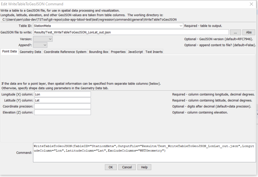
WriteTableToGeoJSON Command Editor for Point Data Parameters (see also the full-size image)
The following figure illustrates the command syntax for layers specified with a geometry data column.
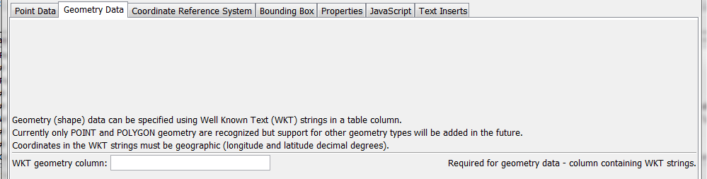
WriteTableToGeoJSON Command Editor for Geometry Data Parameter (see also the full-size image)
The following figure illustrates the command syntax for coordinate reference system parameter.
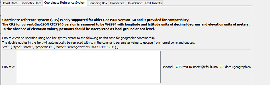
WriteTableToGeoJSON Command Editor for Coordinate Reference System Parameter (see also the full-size image)
The following figure illustrates the command syntax for bounding box parameters.
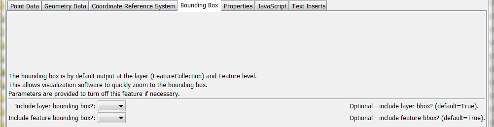
WriteTableToGeoJSON Command Editor for Bounding Box Parameters (see also the full-size image)
The following figure illustrates the command syntax for specifying table columns to include as properties in the GeoJSON output.
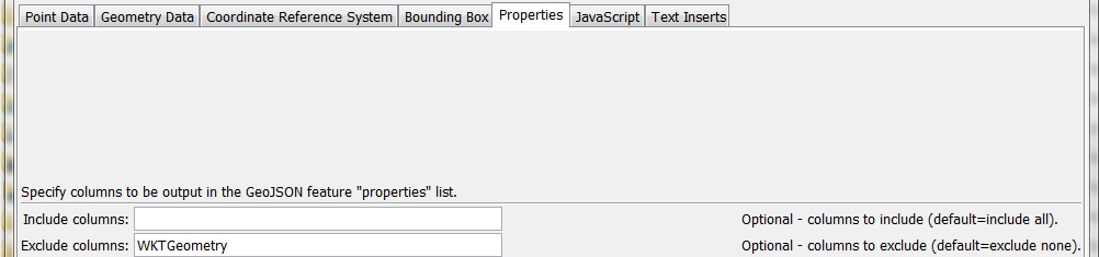
WriteTableToGeoJSON Command Editor for Property Parameters (see also the full-size image)
The following figure illustrates the command syntax for specifying the JavaScript variable for the output object.
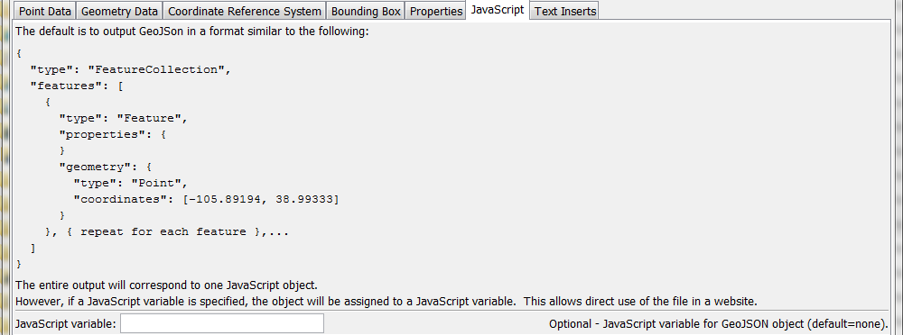
WriteTableToGeoJSON Command Editor for JavaScript Parameters (see also the full-size image)
The following figure illustrates the command syntax for specifying inserts before and after the GeoJSON content.

WriteTableToGeoJSON Command Editor for Text Insert Parameters (see also the full-size image)
Command Syntax
The command syntax is as follows:
WriteTableToGeoJSON(Parameter="Value",...)
Command Parameters
| Parameter | Description | Default |
|---|---|---|
TableID |
Identifier for the table to write. Can be specified using ${Property} notation. |
None – must be specified. |
OutputFile |
The name of the GeoJSON file to write, as an absolute path or relative to the command file location. Can be specified using ${Property} notation. |
None – must be specified. |
Version |
GeoJSON version to write:
|
RFC4976 |
Append |
Indicate whether to append the GeoJSON content to the output file, True or False. |
False |
LongitudeColumn |
The name of the table column that contains longitude. Can be specified using ${Property} notation. |
None – must be specified. |
LatitudeColumn |
The name of the table column that contains latitude. Can be specified using ${Property} notation. |
None – must be specified. |
CoordinatePrecision |
The number of digits to output after the decimal, for coordinates and bounding box. | Precision is based on each data value. |
ElevationColumn |
The name of the table column that contains elevation. Can be specified using ${Property} notation. |
Elevation is omitted. |
WKTGeometryColumn |
The name of the table column that contains Well Known Text (WKT) geometry strings. Can be specified using ${Property} notation. |
|
CRSText |
Only used if Version is 1.0 - Full text to define the coordinate reference system using the crs GeoJSON property. The text will be inserted at the top level of the GeoJSON. This should be used when other than geographic coordinates are used. For more information, see: |
No crs property is included which means that GeoJSON defaults to WGS84 (Version 1.0 default was EPSG:4326, geographic). |
IncludeBBox |
Indicate whether to include bbox GeoJSON property for the full layer. | True |
IncludeFeatureBBox |
Indicate whether to include bbox GeoJSON property for each feature. |
True |
IncludeColumns |
List of comma-separated table column names to include as feature properties. Can be specified using ${Property} notation. | Include all columns. |
ExcludeColumns |
List of comma-separated table column names to exclude as feature properties. Can be specified using ${Property} notation. | Exclude no columns. |
JavaScriptVar |
Name of JavaScript variable to assign object to in output. This parameter will be ignored if PrependText or AppendText are specified. Can be specified using ${Property} notation. |
Output GeoJSON object surrounded by { }. |
PrependText |
Provide text to insert before the GeoJSON object, for example to provide custom JavaScript. Can be specified using ${Property} notation. |
No insert. |
AppendText |
Provide text to append after the GeoJSON object, for example to provide custom JavaScript. Can be specified using ${Property} notation. |
Examples
See the automated tests.
The following example illustrates a CSV table that specifies WKT for points (see WKTGeometry column):
"ID","ID_text","Lon","Lat","Name","WKTGeometry"
50263,050263,-105.891940,38.993330,ANTERO RSVR,"POINT (-105.891940 38.993330)"
50454,050454,-105.476670,39.404720,BAILEY,"POINT (-105.476670 39.404720)"
50848,050848,-105.266670,39.991940,BOULDER,"POINT (-105.266670 39.991940)"
The following example illustrates a CSV table that specifies WKT for polygons:
"ID","ID_text","Lon","Lat","Name","WKTGeometry"
50263,050263,-105.891940,38.993330,ANTERO RSVR,"POLYGON (-105.891940 38.993330,-106 39,-106 37.5)"
50454,050454,-105.476670,39.404720,BAILEY,"POLYGON (-105.476670 39.404720, -104 39, -103 37.5)"
Troubleshooting
See Also
WriteTableToKmlcommandWriteTableToShapefilecommandWriteTimeSeriesToGeoJSONcommand