TSTool / Command / WriteTimeSeriesToGeoJSON
Overview
The WriteTimeSeriesToGeoJSON command writes time series to a GeoJSON file,
which is a spatial data format that can be viewed in geographic information system (GIS) software and other visualization tools. See:
The time series must have properties for longitude and latitude or Well Known Text (WKT) geometry string. See:
Currently only point and polygon data can be processed but in the future support for well-known text for other geometry types will be added. A future enhancement of this command will allow the geometry feature data to be read from other spatial formats.
Command Editor
The following dialog is used to edit the command and illustrates the syntax of the command.

WriteTimeSeriesToGeoJSON Command Editor (see also the full-size image)
The following figure illustrates the command syntax for layers specified with a WKT geometry property.
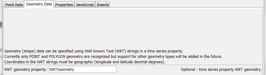
WriteTimeSeriesToGeoJSON Command Editor for WKT Geometry Data Parameters (see also the full-size image)
The following figure illustrates the command syntax for specifying time series properties to include as properties in the GeoJSON output.
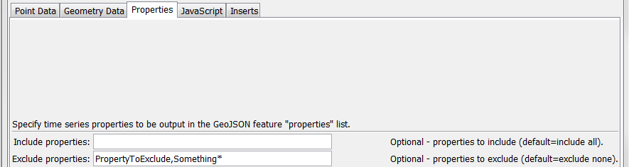
WriteTimeSeriesToGeoJSON Command Editor for Property Parameters (see also the full-size image)
The following figure illustrates the command syntax for specifying the JavaScript variable for the output.
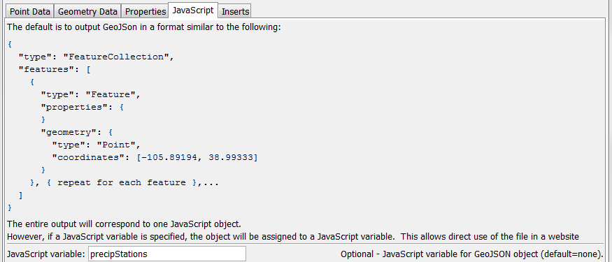
WriteTimeSeriesToGeoJSON Command Editor for JavaScript Parameters (see also the full-size image)
The following figure illustrates the command syntax for specifying inserts around the GeoJSON content.
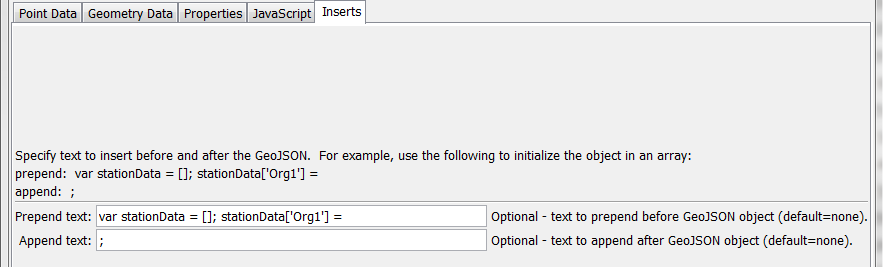
WriteTimeSeriesToGeoJSON Command Editor for Text Insert Parameters (see also the full-size image)
Command Syntax
The command syntax is as follows:
WriteTimeSeriesToGeoJSON(Parameter="Value",...)
Command Parameters
| Parameter | Description | Default |
|---|---|---|
TSList |
Indicates the list of time series to be processed, one of:
|
AllTS |
TSID |
The time series identifier or alias for the time series to be processed, using the * wildcard character to match multiple time series. Can be specified using ${Property}. |
Required if TSList=*TSID |
EnsembleID |
The ensemble to be processed, if processing an ensemble. Can be specified using ${Property}. |
Required if TSList=*EnsembleID |
OutputFile |
The GeoJSON output file. The path to the file can be absolute or relative to the working directory (command file location). Global properties can be used to specify the filename, using the ${Property} syntax. |
None – must be specified. |
Append |
Indicate whether to append the GeoJSON content to the output file, True or False. |
False |
LongitudeProperty |
The name of the time series property containing the longitude to use for the GeoJSON. Can be specified using ${Property}. |
Required unless WKT geometry is specified. |
LatitudeProperty |
The name of the time series property containing the latitude to use for the GeoJSON. Can be specified using ${Property}. |
Required unless WKT geometry is specified. |
CoordinatePrecision |
The number of digits to output after the decimal, for coordinates and bounding box. | Precision is based on each data value. |
ElevationProperty |
The name of the time series property containing the elevation to use for the GeoJSON. Can be specified using ${Property}. |
Omitted |
WKTGeometryProperty |
The name of the time series property that contains Well Known Text (WKT) geometry strings. Can be specified using ${Property}. |
Will use point data properties |
IncludeColumns |
List of comma-separated time series property names to include as feature properties, using * for wildcard. Can be specified using ${Property}. |
Include all columns. |
ExcludeColumns |
List of comma-separated time series property names to exclude as feature properties. Can be specified using ${Property}. |
Exclude no columns. |
JavaScriptVar |
Name of JavaScript variable to assign object to in output. This parameter will be ignored if PrependText or AppendText are specified. Can be specified using ${Property}. |
Output GeoJSON object surrounded by { }. |
PrependText |
Provide text to insert before the GeoJSON object, for example to provide custom JavaScript. Can be specified using ${Property} notation. |
No insert. |
AppendText |
Provide text to append after the GeoJSON object, for example to provide custom JavaScript. Can be specified using ${Property} notation. |
No insert. |
Examples
See the automated tests.
Troubleshooting
See Also
SelectTimeSeriescommandWriteTableToGeoJSONcommandWriteTimeSeriesToKmlcommand