StateDMI / Command / SetCropPatternTS
Overview
The SetCropPatternTS command (for StateCU)
sets crop pattern time series data for a CU Location.
The combination of location ID, crop type, and year identify the data.
It is recommended that the
SetCropPatternTSFromList
command be used if many values are set, which also allows sharing the data file with
SetIrrigationPracticeTSFromList commands.
Command Editor
There have historically been two use cases for this command, as described below. As of StateDMI version 5, only the first use is recommended because irrigated area can now be processed using parcel data.
Use Case 1: Specify crop data to override (or supply) crop pattern data for a structure
In this case, the specified data will be visible as the final data values in output
(and will not be considered when irrigated lands parcels are processed).
The ProcessWhen parameter should be blank or Now, which is the default value.
In this case, the SetCropPatternTS commands should be specified after
ReadCropPatternTSFromParcels,
ReadCropPatternTSFromHydroBase or other similar commands.
It is recommended that for StateDMI 5.x and later that parcel data issues
are corrected using the
SetParcel command so that resulting corrected data is used in the processing workflow
as if the data were read from input sources.
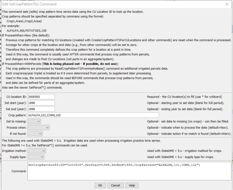
SetCropPatternTS Command Editor (to edit crop pattern time series) (see also the full-size image)
Use Case 2: Specify crop data for a location, to be processed with parcel data
For StateDMI 5.x it is recommended to use the
SetParcel command.
This command was used to set parcel data but setting parcel data directly is more appropriate
because parcel data are used to create multiple model files.
For example, an irrigated lands assessment using GIS might show zero acreage
for a ditch but other information indicates that the ditch irrigates lands.
The ditch may be an individual (key) structure or may be part of an aggregate/system.
In this case, the specified data values contribute to the final data values in output.
The following dialog is used to edit the command and illustrates the syntax of the command.
The years typically agree with an irrigated lands assessment and the
ProcessWhen value must be specified as WithParcels.
In this case, the
SetCropPatternTS commands should be specified before
ReadCropPatternTSFromHydroBase or other similar commands.
The data will be processed as if they were read from HydroBase.
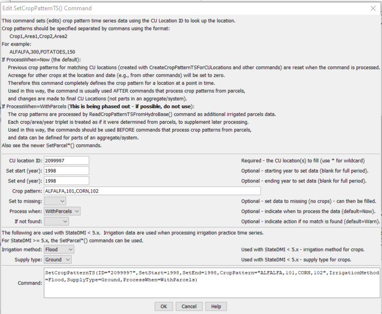
SetCropPatternTS Command Editor (to specify parcel information) (see also the full-size image)
Command Syntax
The command syntax is as follows:
SetCropPatternTS(Parameter="Value",...)
Command Parameters
| Parameter | Description | Default |
|---|---|---|
ID |
A single CU Location identifier to match or a pattern using wildcards (e.g., 20*). |
None – must be specified. |
SetStart |
The first year to set data values. | If not specified, data are set for the full output period. |
SetEnd |
The last year to set data values. | If not specified, data are set for the full output period. |
CropPattern |
A sequence of crop type and area values, to set as data for the specified period. | None – must be specified. |
SetToMissing |
Indicate whether the crop pattern for the specified years should be set to missing, instead of supplying data values. This was used in the Río Grande as follows: Read 1936, 1998, and 2002 data, resulting in crop pattern time series. It is necessary to include all years in order to get a complete list of crops over the period, even if zero or missing in some years. After reading all years, 2002 is set to missing using this command and a standard filling approach is used for the full period. Then, 2002 is read at the end. The overall result is that 2002’s crops are listed in the full period but only have non-zero observations in 2002. | False |
ProcessWhen |
Indicates when the specified data values should be processed. If the parameter value is WithParcels, then the values will be considered when irrigated lands data are processed with later ReadCropPatternTSFromHydroBase. |
Now, indicating that the acreage should be set when the command is processed (not when later read commands are processed). |
IfNotFound |
Used for error handling, one of the following:
|
Warn |
IrrigationMethod |
Used with use case 2 (described above). The irrigation method for specified crops:
SetParcel, SetParcelSurfaceWaterSupply, and SetParcelGroundWaterSupply are more appropriate to set supply data. |
|
SupplyType |
Used with use case 2 (described above). The supply type for specified crops:
SetParcel, SetParcelSurfaceWaterSupply, and SetParcelGroundWaterSupply are more appropriate to set supply data. |
Examples
See the automated tests.
Troubleshooting
See the main troubleshooting documentation
See Also
FillCropPatternTSConstantcommandFillCropPatternTSInterpolatecommandFillCropPatternTSRepeatcommandFillCropPatternTSUsingWellRightscommandReadCropPatternTSFromHydroBasecommandSetCropPatternTSFromListcommandSetParcelcommandSetParcelGroundWaterSupplycommandSetParcelSurfaceWaterSupplycommand