StateDMI / Command / SetWellSystemFromList
Overview
The SetWellSystemFromList command (for StateCU and StateMod) sets well system part identifier data for:
- a CU Location that corresponds to a location with well supply
- or a StateMod well station
Well systems are specified using a list of part identifiers as follows:
- Part type is Ditch
- The collection includes wells that are associated with a list of ditches, identified using ditch water district identifiers (WDIDs). The list of ditches is used for the full period.
- Part type is Parcel
- The collection includes wells that are associated with a list of parcels. The division and year must be specified in the command because well to parcel relationships are determined for specific years.
- This approach was used in the past for all basins but is being phased out and is currently only used for Rio Grande. It may also be phased out for the Rio Grande
- Part type is Well
- The collection includes wells identified by well WDID or well permit receipt.
- The PartIdTypeColumn parameter must be specified to indicate the part ID type.
- This approach is being phased in and is preferred.
To facilitate processing, the list of parts is specified in a delimited list file.
Systems by convention have their water rights fully represented in output.
To aggregate water rights at a location, use an aggregate
(see the similar SetWellAggregateFromList and
SetWellAggregate
commands).
See also the StateDMI Introduction chapter,
which provides additional information about systems and other modeling conventions.
System information should be specified after well locations are defined
and before their use in other processing, such as reading data from HydroBase.
Well parcel data are queried in bulk when first requested and are cached to speed later processing. One level of caching is water district, which is available for all wells. The water district can be determined from a WDID but well receipts require querying to match the receipt and then use the matching WD. This step is performed when a system is defined so that later data access can use the WD.
Command Editor
The following dialog is used to edit the command and illustrates the command syntax.
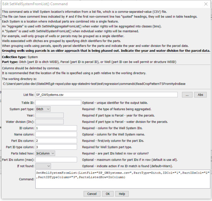
SetWellSystemFromList Command Editor (see also the full-size image)
Command Syntax
The command syntax is as follows:
SetWellSystemFromList(Parameter="Value",...)
Command Parameters
| Parameter | Description | Default |
|---|---|---|
ListFile |
The name of the input file to read, surrounded by double quotes. | None – must be specified. |
TableID |
The table identifier for table read from the list file, useful to confirm input. | |
PartType |
Indicate the type of features being aggregated and specified by PartIDs, one of:
|
None – must be specified. |
Year |
The year defining the parcels. | Required when PartType is Parcel because parcel identifiers from well matching are specific to the data year. |
Div |
Water division for the parcels in the system. | Required when PartType is Parcel because parcels require the division. |
IDCol |
The column number (1+) or name containing the well system identifiers. | None – must be specified. |
NameCol |
The column number (1+) or name containing the well system name. | None – optional (name will remain as before). |
PartIDsCol |
The column number (1+) or name for the first column having part identifiers. | None – must be specified. |
PartIdTypeColumn |
The column number (1+) or name or name for the column having part ID type. Recognized values in the column cells are WDID to indicate water district identifier and Receipt indicating a well permit receipt. Values are not case-sensitive. |
Required when specifying system using Well part type. |
PartsListedHow |
If InRow, it is expected that all parts defining a system are listed in the same row. If InColumn, it is expected that the parts defining a system are listed one per row, with multiple rows defining the full system (PartIDsColMax is ignored in this case). |
None – must be specified. |
PartIDsColMax |
The column number (1+) or name for the last column having part identifiers. Use if extra columns on the right need to be excluded from the list. | Use all available non-blank columns starting with PartIDsCol. |
IfNotFound |
Used for error handling, one of the following:
|
Warn |
Examples
See the automated tests.
The following example illustrates a list file is used with PartType=Parcel and PartsListedHow=InColumn:
"UZONES","PARCEL"
20URF0,16831
20URF0,16832
20URF0,16834
…
20URF0,18606
20URF24,10295
20URF24,10318
...
The following example illustrates a list file is used with PartType=Ditch and PartsListedHow=InColumn, with the name being provided in column 2:
# System_ID/Agg_Name/WDID
01_ADP037,South Platte River below Kersey Co North 2,0100643
01_ADP037,South Platte River below Kersey Co North 2,0100644
01_ADP037,South Platte River below Kersey Co North 2,0100835
01_ADP037,South Platte River below Kersey Co North 2,0104486
The following example illustrates a list file is used with PartType=Ditch and PartsListedHow=InColumn,
with the name being provided in column 2,
and column names specified as quoted strings so that column names (rather than numbers) can be specified for parameters.
"Aggregate_ID","Agg_Name","WDID"
01_ADP037,South Platte River below Kersey Co North 2,0100643
01_ADP037,South Platte River below Kersey Co North 2,0100644
01_ADP037,South Platte River below Kersey Co North 2,0100835
01_ADP037,South Platte River below Kersey Co North 2,0104486
The following example illustrates a list file for PartType=Well and PartsListedHow=InColumn,
with the part ID type specified in column 2, and part ID type in column 3:
# List file created by intersecting the well coverages (that are included in the CDSS
# irrigated acreage GDB) with the GW Aggregate Coverage,
# removing duplicates, and limiting the list to only wells tied to a GW only irrigated
# parcel in any of the acreage snapshots.
# Files/versions used include:
#  HydroBase_CO_20160407
#  SPDSS GIS Coverages 3/30/2016
#  Aggregate_03_2008.shp
#GWID,WELL_ID,ID_TYPE
01_AWP022,0000072A,RECEIPT
01_AWP022,0000218A,RECEIPT
01_AWP012,0003643,RECEIPT
01_AWP022,0004850C,RECEIPT
03_AWP001,0013828,RECEIPT
01_AWP003,0105001,WDID
01_AWP003,0105003,WDID
01_AWP002,0105005,WDID
01_AWP002,0105006,WDID
01_AWP027,0105012,WDID
Troubleshooting
See the main troubleshooting documentation
See Also
SetWellAggregatecommandSetWellAggregateFromListcommandSetWellSystemcommand